About Jackfish lake
Information from Alberta Lakes Atlas, Department of Earth & Atmospheric Sciences, University of Alberta, 1990
Source: http://albertalakes.ualberta.ca/?page=lake&lake=80®ion=3
Introduction
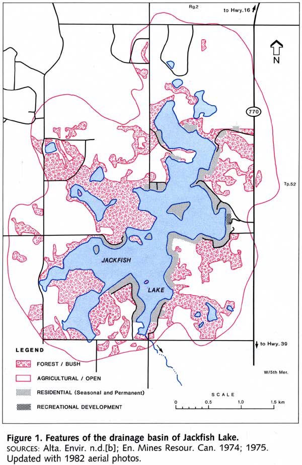
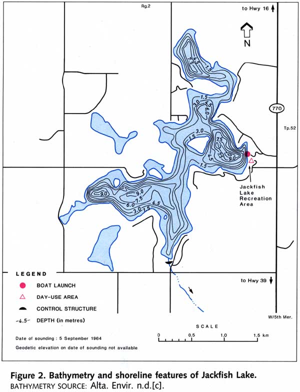
Jackfish Lake is an attractive recreational lake located in the County of Parkland, approximately 60 km west of the city of Edmonton and 25 km west of the town of Stony Plain. To reach the lake from Edmonton, take Highway 16 west for 50 km to Secondary Road 770 and drive south for about 10 km to the east side of the lake. Several local roads provide access to residential developments along the lakeshore (FIGURE 1). Public access to the water is available only at the county-owned Jackfish Lake Recreation Area on the eastern shore (FIGURE 2). Facilities include a day-use area with 16 picnic sites, parking and a boat launch.
The origin of the lake’s name and the local history of the area near the lake have not been documented, but the name likely came from the target of the sport fishery, the northern pike, which are popularly known as jackfish.
Blue-green algae turn the water in Jackfish Lake green in July and August and aquatic vegetation grows densely in shallow areas. The major recreational activities are picnicking, water skiing, boating, and fishing for northern pike, yellow perch and walleye. Swimming is popular, but there is no sandy beach. Provincial sport fishing regulations prohibit fishing for bait fish or the use of bait fish in Jackfish Lake (Alta. For. Ld. Wild. 1989). Conflicts have occurred between recreational groups on this busy lake-anglers and swimmers need quiet areas away from power boats and water skiers. The county has been looking for a solution to this problem, but by 1988 no decisions had been reached and no boating restrictions were in place (Alta. For. Ld. Wild. 1988). Regulations proposed include a 12 km/hour speed limit in front of the boat launch and designation of a swimming area where no boats are allowed.
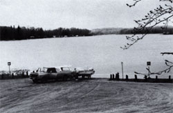
Photo credit: unknown
Lat / Long | 53.4833333, -114.2500000 |
Area | 2.39 km2 |
Max depth | 9 m |
Mean depth | 3.4 m |
Dr. Basin Area | 12.6 km2 |
Dam, Weir | Weir |
Drainage Basin | North Saskatchewan River Basin |
Camp Ground | None |
Boat Launch | Present |
Sport Fish | Northern Pike, Walleye, Yellow Perch |
Trophic Status | Eutrophic |
TP x | 39 µg/L |
CHLORO x | 10.9 µg/L |
TDS x | 600 mg/L |
Drainage Basin Characterisitics
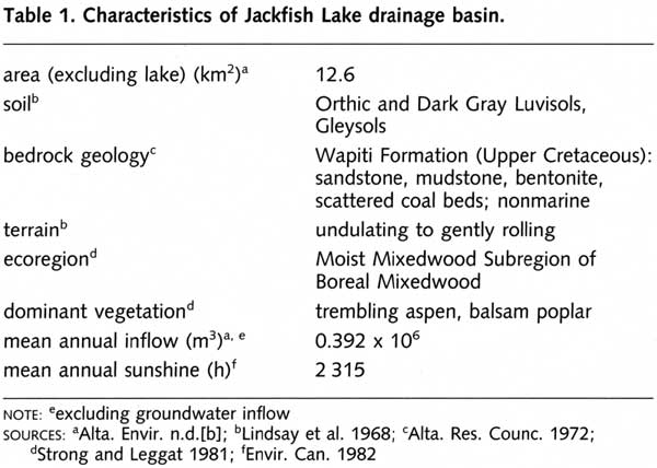
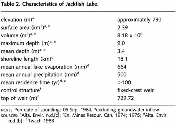
Jackfish Lake has a small drainage basin that is about 5 times the size of the lake (Tables 1, 2). There are no defined inlets to the lake, so most inflow comes from precipitation and groundwater. The outlet flows intermittently. Most of the land in the watershed is gently undulating, but localized areas are hummocky and consist of steep-sided knolls with slopes greater than 15%. Slopes are steep along most of the shoreline of the lake and around the larger sloughs nearby (Bird and Hale 1976). Elevations range from 762 m on the eastern side of the drainage basin to 730 m on the shore of Jackfish Lake. Most of the surficial deposits are clay, silt and fine sand either in stratified layers or in a homogeneous mixture. Soils are mainly well-drained Orthic Gray and Dark Gray Luvisols that formed on deltaic parent material (Lindsay et al. 1968). Shallow deposits of Organic soils have accumulated in some of the larger sloughs and in areas adjacent to the shore of the lake (Bird and Hale 1976).
Jackfish Lake’s drainage basin is part of the Moist Mixedwood Subregion of the Boreal Mixedwood Ecoregion (Strong and Leggat 1981). Approximately 60% of the drainage basin has been cleared for agricultural use, but extensive wooded areas remain close to the lake (FIGURE 1). Most of the natural vegetation has been disturbed by human activity and is in a state of regeneration. The dominant species are trembling aspen and balsam poplar, which are interspersed with willow, birch and white spruce (R.L. & L. Envir. Serv. Ltd. 1987). A large part of the cleared land is used for annual crops and livestock pasture. At the north end of the lake, livestock are pastured and watered along the shore.
Approximately 42% of the shoreline, including islands, is developed. Eight subdivisions and a number of leased properties have been developed near the lake and on three of the five islands around the lake. The remaining, undeveloped islands are popular picnicking spots for visitors. In 1981, there were about 235 residences and trailers at the lake, of which only 20% were permanent.
Lake Basin Characteristics
Jackfish Lake is a small (2.4 km2, TABLE 2), shallow lake with a very irregular shoreline (FIGURE 2). The five islands in the lake have a combined surface area of approximately 0.1 km2. The lake bottom is also irregular: there are three distinct basins, two of which are 9-m deep. In shallower areas, the sediment is mainly sand, although localized areas of clay are also present. There are a few areas of gravel and rubble substrate suitable for walleye spawning (R.L. & L. Envir. Serv. Ltd. 1987).
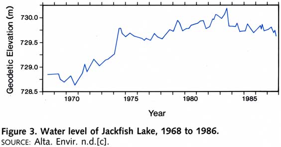
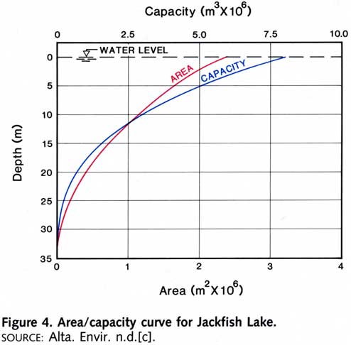
For many years prior to 1983, Jackfish Lake had no defined outlet. Historically, a stream had flowed from the southeast basin, but the outlet had been blocked for many years. Residents at the lake were concerned about high water levels in the early 1980s because the lake’s elevation had been rising steadily for more than a decade (FIGURE 3). From 1970 to 1982, the water level rose by 1.4 m. Changes in the lake’s area and capacity with variations in water level are shown in Figure 4. In the winter of 1982/83, the County of Parkland reestablished outflow by clearing the old stream bed and constructing a culvert under a road near the southeast basin (Twach 1988). During the winter of 1982/83, the county built a concrete cut-off wall that forms a low fixed-crest weir at the inlet to the culvert. Water drains over the top of the weir when lake levels surpass 729.72 m. Since 1983, however, the lake’s elevation has declined slightly, and consequently, water has flowed from the lake only intermittently.
Section Subtitle
Want to work with us?
Soko radicchio bunya nuts gram dulse silver beet parsnip napa cabbage lotus root sea lettuce brussels sprout cabbage.
Catsear cauliflower garbanzo yarrow salsify chicory garlic bell pepper napa cabbage lettuce tomato kale arugula melon sierra leone bologi rutabaga tigernut. Jícama garlic courgette coriander radicchio plantain scallion cauliflower fava bean desert raisin.
We are currently looking for the following positions:
- Lead developer
- Client manager
- Marketing Specialist
Water Quality
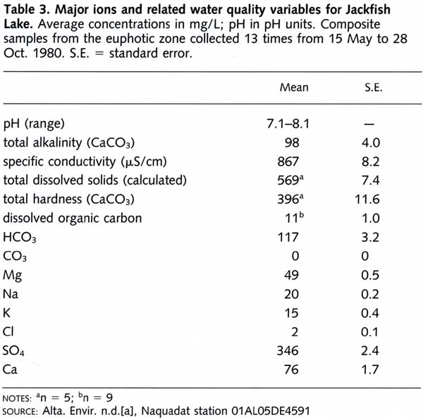
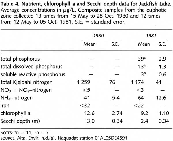
The water quality of Jackfish Lake was examined by Alberta Environment in 1980 and 1981 (Alta. Envir. n.d.[a]; 1989). As well, dissolved oxygen concentrations were measured by Fish and Wildlife Division in March 1983. Although the lake water is fresh, the level of total dissolved solids is slightly higher than in most freshwater lakes, but well within the range of the smaller lakes in the County of Parkland. The water is very hard, but the alkalinity is relatively low for a prairie lake (TABLE 3). The dominant ions are calcium and sulphate. The high sulphate levels probably reflect the influence of groundwater inflow.
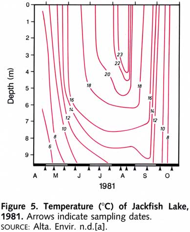
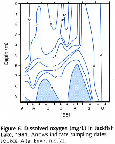
The water column probably did not mix completely in the spring of 1981, as indicated by the weak thermal stratification (FIGURE 5) and the anoxia near the bottom sediments (FIGURE 6) in early May. Thermal stratification and anoxia below depths of 6 to 7.5 m continued through the summer until September. After turnover in late September, the water column was almost fully saturated with dissolved oxygen. Under ice cover in March 1983, the water was anoxic below 4 m in all basins, and surface concentrations of dissolved oxygen did not exceed 2.2 mg/L.
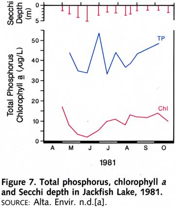
Large fluctuations in total phosphorus concentrations were recorded throughout the summer of 1981 (FIGURE 7). Chlorophyll a concentrations were less erratic; the highest peak (17 µg/L) occurred in early May after partial mixing of the water column took place. The trophic status of Jackfish Lake is not easily determined, but the lake is probably best characterized as eutrophic. Maximum chlorophyll a levels vary considerably from year to year. For example, the highest value in 1980 was 32 µg/L in September, almost double the 1981 peak level, detected in May. Average chlorophyll a levels (TABLE 4) were also higher in 1980 (12.6 µg/L) than in 1981 (9.2 µg/L).
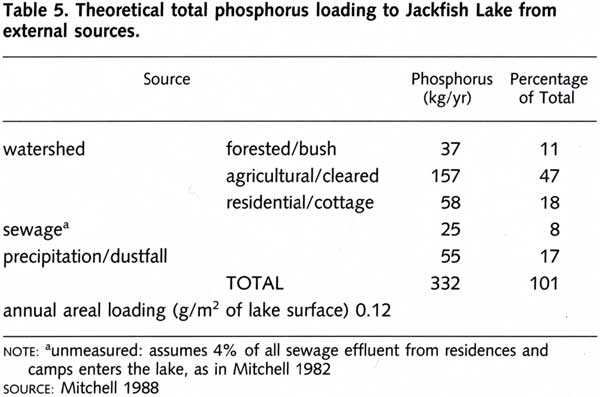
The external load of total phosphorus to Jackfish Lake is estimated to be 332 kg/year, or 0.12 g/m2 of lake area (TABLE 5). This rate is lower than those calculated for hyper-eutrophic lakes such as Lac la Nonne (0.41 g/m2 per year), but is higher than less productive lakes such as Marie (0.08 g/m2 per year). Most of the external phosphorus loading to Jackfish Lake originates from runoff from agricultural land, runoff from residential developments, and precipitation and dustfall. Runoff from forested areas and inputs of sewage effluent provided smaller amounts of phosphorus. Loading from sewage was not measured on Jackfish Lake – it was calculated from data collected for other Alberta lakes. Phosphorus inputs from groundwater and sediment release have not been quantified, but they are likely to be important.
Biological Characteristics
Plants
The phytoplankton community has not been studied in detail. The relative abundance of net phytoplankton was determined by Fish and Wildlife Division on 9 August 1966 (Hunt 1966). The blue-green genera Lyngbya, Coelosphaerium, Anacystis and Anabaena were most abundant, whereas diatoms and desmids were present but not abundant.
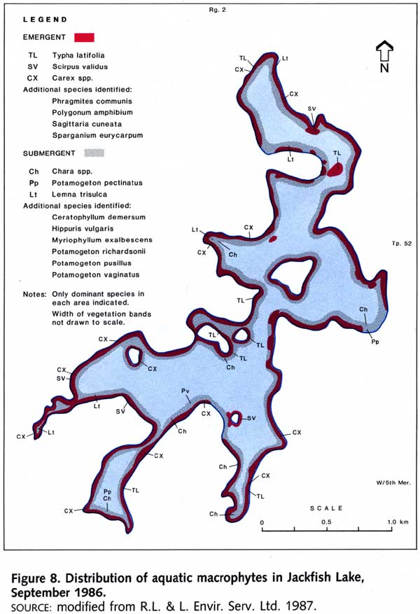
A survey of the aquatic macrophyte community was conducted for the provincial government in September 1986 (FIGURE 8). The emergent vegetation in the shallow inshore areas was dominated by sedges (Carex spp.) and common cattail (Typha latifolia), with numerous patches of common great bulrush (Scirpus validus). Areas from 1- to 5-m deep supported extensive growths of submergent plants. The dominant species, stonewort (Chara spp.), was present around the entire perimeter of the lake. Sago pondweed (Potamogeton pectinatus), northern watermilfoil (Myriophyllum exalbescens) and large-sheath pondweed (Potamogeton vaginatus) were present at low densities over most of the littoral zone, and star duckweed (Lemna trisulca) was frequently encountered in scattered clusters.
Invertebrates
The zooplankton community was sampled with a net by Fish and Wildlife Division on 9 August 1966 (Hunt 1966). The most abundant animals were the crustacean Diaptomus and the rotifer Keratella. During the same survey, the benthic community was sampled at 8 depths between 3.5 m and 9 m (sample size unknown). At the 3.5-m depth, snails (Gastropoda: Planorbidae and Lymnaedae), scuds (Amphipoda: Gammaridae) and midge larvae (Diptera: Chironomidae) were most abundant, and small numbers of caddis fly larvae (Trichoptera) and leeches (Hirudinea) were present. At depths greater than 5 m, phantom midge larvae (Diptera: Chaoborus) were most abundant.
Fish
The fish species present in Jackfish Lake are northern pike, yellow perch, walleye, brook stickleback, spottail shiner and Iowa darter. Populations of northern pike and yellow perch are large enough to sustain a sport fishery. Walleye are present in limited numbers, perhaps because of angling pressure and lack of suitable spawning habitat (R.L. & L. Envir. Serv. Ltd. 1987).
In a 1986 survey for the provincial government (R.L. & L. Envir. Serv. Ltd. 1987), northern pike was the dominant species captured in gill nets (71% of the total catch). The length-at-age of northern pike in Jackfish Lake was similar to that of populations in Lesser Slave, Hilda, Hubbies and Mere lakes. The oldest pike sampled were 7 years old, with an average length of 618 mm and an average weight of 1,654 g. Ample spawning habitat for northern pike and yellow perch is provided by the extensive beds of aquatic macrophytes along the lakeshore. Yellow perch in Jackfish Lake were smaller at a given age than perch from Mere, Hubbies and Muir lakes. The growth of Jackfish Lake perch was typical of other stunted populations; that is, the fish were less than 160 mm in total length by age 3. The oldest perch caught was a seven-year-old specimen that was 177-mm long.
In 1982, a creel survey at Jackfish Lake was conducted over a seven-day period in June (Alta. For. Ld. Wild. n.d.). The 42 anglers interviewed fished for 51 hours and caught 19 northern pike (0.37 fish/hour), 11 yellow perch (0.21 fish/hour) and 2 walleye (0.04 fish/hour). Most of the anglers fished from large boats rather than from shore.
Wildlife
There is no information available on the wildlife at Jackfish Lake.
M.E. Bradford
References
Alberta Environment. n.d.[a]. Envir. Assess. Div., Envir. Qlty. Monit. Br. Unpubl. data, Edmonton.
—–. n.d.[b]. Tech. Serv. Div., Hydrol. Br. Unpubl. data, Edmonton.
—–. n.d.[c]. Tech. Serv. Div., Surv. Br. Unpubl. data, Edmonton.
—–. 1989. Jackfish Lake. Envir. Assess. Div., Envir. Qlty. Monit. Br., Edmonton.
Alberta Forestry, Lands and Wildlife. n.d. Fish Wild. Div. Unpubl. data, Edmonton.
—–. 1988. Boating in Alberta. Fish Wild. Div., Edmonton.
—–. 1989. Guide to sportfishing. Fish Wild. Div., Edmonton.
Alberta Research Council. 1972. Geological map of Alberta. Nat. Resour. Div., Alta. Geol. Surv., Edmonton.
Bird and Hale Ltd. 1976. Development capability study for Jackfish and Mayatan Lakes. Prep. for Alta. Envir., Ld. Conserv. Reclamation Div., Reg. Ld. Use Br., Edmonton.
Energy, Mines and Resources Canada. 1974, 1975. National topographic series 1:50 000 83G/9 (1974), 83G/8 (1975). Surv. Map. Br., Ottawa.
Environment Canada. 1982. Canadian climate normals, Vol. 7: Bright sunshine (1951-1980). Prep. by Atm. Envir. Serv. Supply Serv. Can., Ottawa.
Hunt, C. 1966. Preliminary lake survey: Jackfish Lake. Alta. Ld. For., Fish Wild. Div., Edmonton.
Lindsay, J.D., W. Odynsky, J.W. Peters and W.E. Bowser. 1968. Soil survey of the Buck Lake (NE 83B) and Wabamun Lake (E1/2 83G) areas. Alta. Soil Surv. Rep. No. 24, Univ. Alta. Bull. No. SS-7, Res. Counc. Alta. Rep. No. 87 1968. Univ. Alta., Edmonton.
Mitchell, P.A. 1982. Evaluation of the “septic snooper” on Wabamun and Pigeon lakes. Alta. Envir., Poll. Contr. Div., Water Qlty. Contr. Br., Edmonton.
—–. 1988. Alta. Envir., Envir. Assess. Div., Envir. Qlty. Monit. Br. Pers. comm.
R.L. & L. Environmental Services Ltd. 1987. County of Parkland fisheries inventory: Jackfish Lake. Prep. for Alta. For. Ld. Wild., Fish Wild. Div. and Alta. Rec. Parks, Rec. Devel. Div., Rec. Parks Wild. Foundation, Edmonton.
Strong, W.L. and K.R. Leggat. 1981. Ecoregions of Alberta. Alta. En. Nat. Resour., Resour. Eval. Plan. Div., Edmonton.
Twach, J. 1988. Co. Parkland No. 31, Stony Plain. Pers. comm.